This site has absolutely nothing to do with Conway, Gwynedd, it is part of the Western Command Carmarthen Stop Line, which runs from Pembrey, Carmarthenshire, in the south, to Llangrannog, Ceredigion, in the north. The village name is Cynwyl Elfed and I’m afraid Philip Knight’s information is, perhaps, not entirely accurate.
“Next to the old rock & Fountain pub on the A484 lies this series of WW2 military reminders. Left is a pill box built onto the side of the reservoir pump house and overlooks the river and railway track on the opposite bank. The pill box on the Right is overlooking the road and the entrance to the reservoir. The brick structure inside is an anti-ricochet wall. It is a type 24 bullet proof pillbox. The entrance to the reservoir SB was also guarded by anti-tank rails. Basically, Upright railway track sections placed either side of the track and in the stream”
The correct name for the former pub was “Tafarn y Roc” or the “Rock and Fountain” and is situated at Allt Foel-fawr, adjacent to Nant Cwm-tawel. The Type-24 pillbox (SN 38972 25882) is raised on a large foundation platform to allow for the steep embankment that carries the A484 road on the western side of the valley and it covered an adjacent roadblock, facing north. Apparently, there was a sniping position high up on the opposite bank. There are two sets of anti-tank obstacles formed by double rows of tram rails up-ended and set in the ground; one blocks off Nant Cwm-tawel valley from the west that descends from Cwm Tawel Reservoir and the other, obstructs the bed of the River Gwili and climbs the embankment of the Carmarthen – Aberystwyth railway on the eastern side of the river, to where there was a railblock. Amazingly the barbed wire entanglement on screw pickets also survives, as do coils of Dannert wire at the side of the road. Incidentally, during the war the publican of Tafarn y Roc used to bring out a bucket of beer on a Sunday for the Home Guardsmen manning the pillbox and roadblock; this would have been a real treat as Carmarthenshire was “dry” on a Sunday right up until the late 1970s. Whether the chapel-going Home Guardsmen would have approved would have been a different matter though.
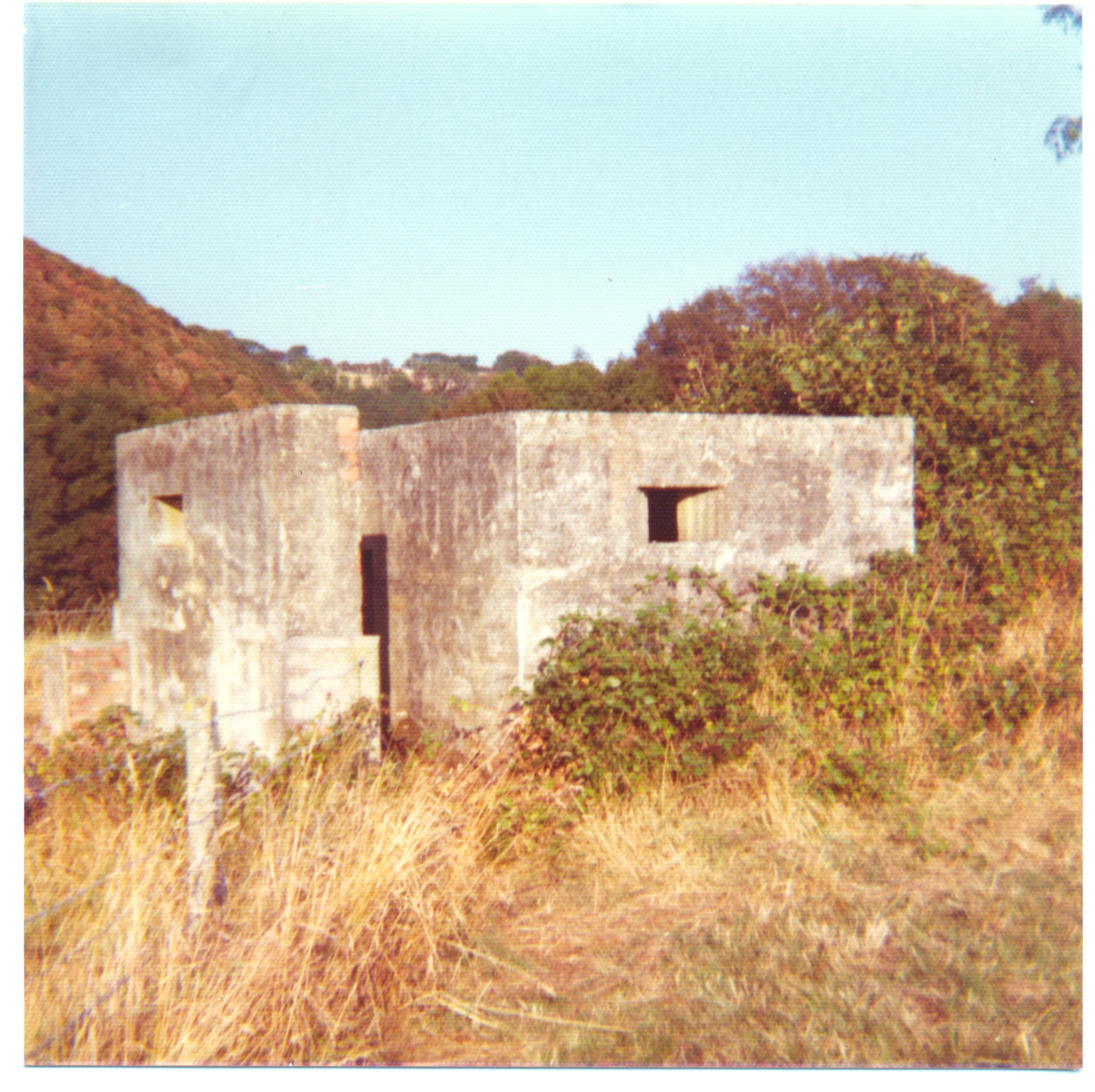
“At the end of the village on the bend of the road lies a Norcon type pillbox. Roofless, sunken & made of pre-cast concrete. Type CP/6/40/111. The two photos show the pillbox located again on the bend in the road on the A484 near the garage. This one was for defending the valley that it faces. The door backs onto the A484. Inside one can find a concrete block for covering up the gun holes (right) and a peculiar brick box on the floor. (bottom right) Also the wooden door is still in good condition. It is classed as a type 24 bullet proof pillbox. They have built the walls from brick and left a gap between the inside and outside skins. Then concrete has been poured in the gap to give it its strength against attack”.
To the South of Cynwyl Elfed, the Nant Ring valley intercepts the Afon Duad valley from the west, this confluence at Pont Nant-Ring and the adjacent roads were obstructed as part of the stop line, an unclassified road and a lane converge on the A484 at this point and were covered by the Norcon pillbox (SN 37369 27060) and the Type-24 pillbox (SN 37356 27075) in the description. Both the confluence and the rising ground to the south of the A484 were obstructed by anti-tank ditches, the one adjacent to the A484 can be seen as a parallel crop mark in the grass on Google Earth. Incidentally, Philip has tried to describe the construction of the Type-24 pillbox without fully understanding why it is built the way it is. The external and internal brick skins functioned, as the shuttering for the bulk of the wall that is reinforced concrete, which of course, is the pillbox proper; the brick shuttering was left it place to give it additional strength, not the other way round as suggested. I suspect that the internal brick box was some form of ammunition locker, possibly for grenades of some description.
“The Home front fitted out this building with bridge defence in mind. The floor boards were strengthened with small gauge railway tracks to accommodate the heavy guns that would have been placed here and firing holes put in the walls. The guns never set foot in the building. A fine example of the UK’s defensive network. The rails that protrude into the road are said to have acted as part of a road block system”.
A stone-built former cobbler’s shop (SN 37314 27479) that was converted into a defence post is adjacent to Pont Cynwyl bridge, that carries the A484 over Nant Gochen at the centre of the village. Philip has included five photos of this structure, but once again has got his facts and text mixed up. “Home front” should read “Home Guard” and it wasn’t for bridge defence, the narrow humped bridge formed an ideal road block. The floor of the former cobbler’s shop has been strengthened using a brick pillar and a rail beam, but not to support heavy guns as suggested, as the loop-holes are set too high in the wall for any such weapons. I have my doubts that there were any heavy weapons there, apart from the building being used as a Home Guard store. The protruding rails were part of the roadblock, and two downward pointing steel brackets are situated in the western face of the opposing parapet wall of the bridge, to hold the obstruction in place. The last two photos are of a semi-sunken Type-24 pillbox (SN 37497 27312) situated at Bron Llwyn, a house set high up on the eastern side of the Afon Duad valley, over-looking both the village, and Pont Nant-Ring. The long slit is not an embrasure, it is a ventilation gap at the top of the blocked doorway. Incidentally, another defence post (SN 37323 27654) still remains in the village, it is a milking parlour that has had an armoured gun embrasure cut into its southern wall, at Penhill Farm, over-looking the A484 at the northern end of the village.
“The purpose of the defences along the A484 in these parts was to defend against an Ireland based invasion. Poppit sands was the likely culprit along with Newport beach one would imagine. Stopping an enemy from gaining ground from such a landing would be paramount, hence the various defence works set up between the Cardigan area and Carmarthen. The concentration of defences outlined here is probably due to the nearby railway station. If a rail link could be captured and secured it would prove most beneficial”.
Philip’s conclusion as to why there are pillboxes along the A484 is correct, i.e. a German attack coming from Ireland (that’s another story in itself – Plan Green), but he hasn’t appreciated the larger picture of these defences being part of a major stop line. The fear was that the Germans would land on the broad sandy beaches of Pembrokeshire, then take Milford Haven as a port for un-loading heavy equipment, before advance to the east. Carmarthenshire and southern Cardiganshire is an area of rolling hills and moorlands, deeply incised by narrow river valleys, particularly the Teifi, Duad, Gwilli, and the Towi, and their tributaries. All of these valleys were intended to act as stop lines, with all bridging points defended and blocked. The land rises to 268m near Bleanantgwyn and is obstructed to the north and south of the Teifi valley by deep glacial over-spill valleys that would have acted as north-south trending anti-tank obstacles. The only place where there is a gap in these valleys is the moorland at Bleanantgwyn, which was heavily defended with substantial artillery-proof pillboxes, long rows of anti-tank cubes, minefields and anti-tank ditches. Once the Germans got stuck in the Duad and Gwilli valleys, they would have been funnelled and would have had to fight all the way down to Carmarthen which was a nodal point.
Regards,
Roger