East Yorkshire
by
Austin J Ruddy
The Holderness area of East Yorkshire stretches 30 miles from Flamborough Head in the north to Spurn Head in the south, and 20 miles inland past Hull, along the river Humber. It is predominantly rural landscape, gently undulating, made up of loamy glacial soil, providing a good basis for farming. The two main coastal towns are Hornsea and Withernsea, with several villages in between, mainly of a dispersed settlement pattern.
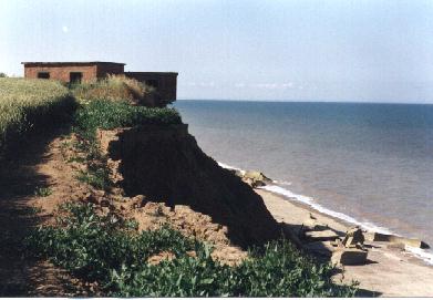
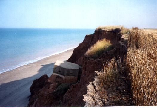
The coast is bounded by crumbling boulder clay cliffs that are continuously eroding at about one metre per year – since 1940, about 60 metres have been lost, meaning that many of the wartime defences have now been destroyed or are underwater. There is continuous beach-line stretching along the whole coast, made up of sand and pebbles from this eroded cliff material.
Historical Background
Previously it had been assumed that any attack on Britain would occur in the south; as General Ironside, C in C Home Forces first thought: “The main landings will undoubtedly be carried out in Kent and East Anglia. All other operations, which may be landings in the Shetlands, Yorkshire will be diversions to get us to move away our main reserves” (MacLeod & Kelly, 1974:380). But with the sudden fall of France and the Benelux Countries – and thus the removal of Britain’s buffer – there is now just 200 miles of sea between Holderness and the Occupied Holland and 300 miles directly east to Germany. The Holderness area with its access to Hull and the Industrial Midlands, had good flat ‘tank country’, as well as several good landing points. Ironside’s view was soon put into doubt by Home Command as the potential grew for German landings in this area.
Threats were made by the German propaganda radio station, the New British Broadcasting Service, that “intensified air raids on the South East of England foreshadowed surprise landings elsewhere, possibly in the North East (Fleming 1958:111). Likewise, the amphibious training of German troops in the Occupied Scandinavian countries was an attempt to “simulate a threat to the coasts of Scotland and Yorkshire” (Ibid:241). Although at the time these threats were purely a German bluff, British Home Forces took them very seriously.
In July 1940, a naval force of three cruisers and seven destroyers were stationed in the Humber to intercept any invasion force (Dorian, 1990: 32) and continuous patrols were flown at night between the Humber and the Nero to detect light surface craft leaving the occupied Dutch ports after sunset (Collier, 1957: 140).
The Local Defensive Response
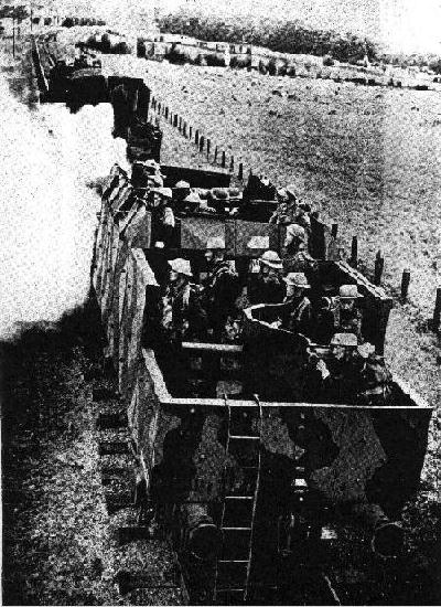
At first, the defensive response was meagre due to a lack of materials, as there was a great demand for defence building in the South of England. One elderly local from Withernsea remembered disdainfully, that all there was to defend the town in June/July 1940, was “a single roll of barbed wire stretched along the beach at the waterline and a single Bren gun on the promenade – the Germans could have rolled in and walked up the beach if they wanted to”. [personal communication: 18/7/94].
It was not until mid-late July 1940 that major defence building actually started.
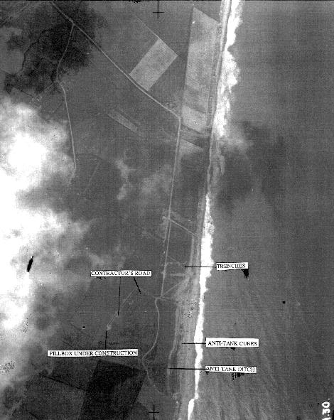
Although much of what was built in the summer of 1940 has since been destroyed by demolition and erosion, and the original construction plans have proved untraceable (if they survived), the military archaeologist has an invaluable source in the form of surviving aerial photographs, archived at the National Monuments Record in Swindon. These photographs help to elaborate field survey work and vice-versa, allowing a much fuller understanding of the `coastal crust` defences. One such example where both survey work and the use of this source have helped considerably in developing an understanding of the defensive response, is at Sand-le-Mere.
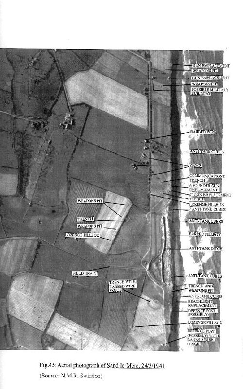
Sand-Le-Mere (NGR TA 319 311)
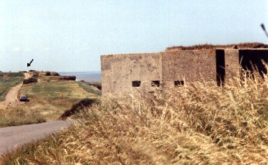
Two miles north of the coastal town of Withernsea, is Sand-le-mere, a field drain outlet. It is the first breach in the tall cliffs (indeed, the only other beach access point is at another field drain outlet at the Runnell, over 5 miles away to the south, and this point is considerably narrower). This breach would have made a very good access point inland for tanks, which could then encircle Withernsea – therefore, it was heavily defended with a full array of fortifications.
 Early Construction
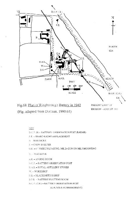
An aerial photograph dated 28th July 1940 clearly shows construction work proceeding at this site. Although the trenches (10) & (12) (see map below) and the anti-tank blocks (14) & anti-tank ditch (16) have been built, work is still progressing on the pillboxes, primarily (25), which clearly has a spoil heap and a rough contractor’s path approaching it.
Possibly due to the lack of time available, no attempt has been made to hide these works, making them highly visible from the air, and clearly ignoring official instructions on the camouflage of construction work [Wills, 1985:63]
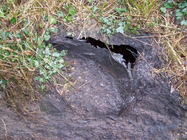
One cannot be exactly sure when the construction work was finished at Sand-le-Mere as there are no documentary sources available. However, field work has revealed one possible completion date. On top of the entrance blast wall at pillbox (26), one of the builders has written in wet concrete his name “C. Nelson” and the date “AUG 22 1940”.
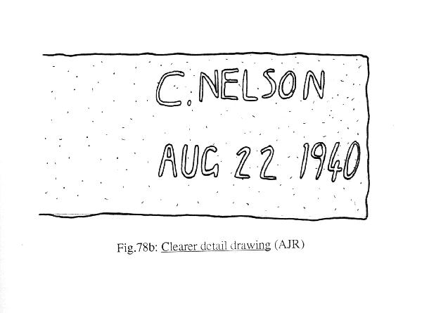
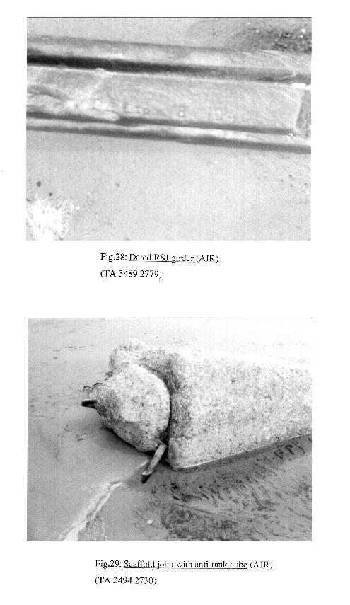
As it appears that the roof was the last section of the pillbox to be cast, then one can probably say that this was the date when the pillbox was finished. Also, a steel rail protruding from an anti-tank block on the beach, has the date “8.1940” stamped on it. As nationally, supplies of steel were low, this meant stockpiles were practically non-existent, so this rail was probably used immediately after manufacture, making the date quite precise.
The Completed Defences
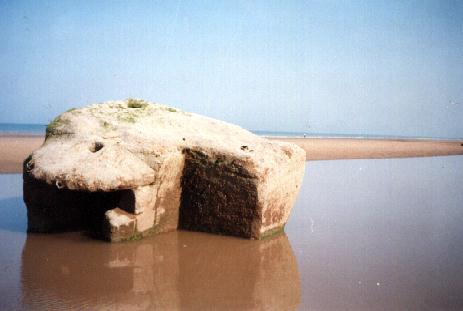
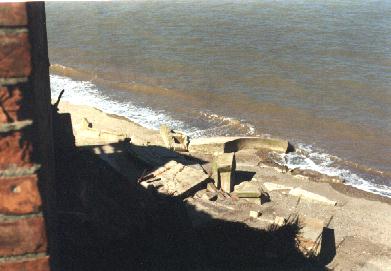
However, it appears that by March 1941, when the second aerial photograph was taken, the defences were fully built. At the top of the beach, blocking the breach in the cliffs, is a double row of anti-tank blocks (140, intermittently spaced face-on), with a single HMG “eared” pillbox in the northern section (15), to provide enfilade fire down the line.
This aerial photograph reveals about 400 A/T blocks, whilst field walking has found about 160 roughly still in position. The rest are submerged under the sand, whilst the “eared” pillbox is long since gone. The so called (by me) “Eared” Heavy Machine Gun Pillbox appears to be a design unique to the East Coast of Yorkshire – unless of course you know different!!!!

Note: numbers in brackets in the text of this article refer directly to the numbered defences in the above drawing.
Both north and south ends of the beach are blocked by a single row of about 15-20 A/T blocks that run perpendicular into the sea (8) & (17). Their purpose was to limit the area available to the invaders and to stop them outflanking the defences.
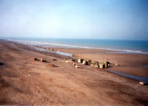
The single row of blocks at the northern end of the beach (8), are built on a 60cm/2ft thick concrete raft to hold them in position, due to their unsteady location. The end of the row is submerged by the sea, but three of these blocks have upright RSJ girders protruding from their tops to tear the tracks off any tank which tried to cross them. The girders also allowed barbed wire to be strung across the blocks. For some reason, the middle section of six blocks are all cast edge-on, whereas the rest are face-on.
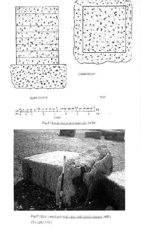
The A/T blocks are generally 1.44m/4ft 8in tall and only 1.18m/3ft 8in in depth and width. As with all the concrete fences, they are made with sand and shingle from the beach and the imprints from the horizontal wood shuttering are generally still visible. An upturned block at (17) shows that the 2cm thick steel strips were used at each corner to reinforce the blocks. Of the two officially recommended sizes of A/T cube – 5ft & 3ft 6in – the Holderness blocks approximately correspond with the latter in plan, varying by a few centimetres. They can not however, be called cubes as the height measurements above show. Unlike Withernsea, there is no evidence to suggest that “Z1” scaffolding barrier was used at Sand-le-Mere.
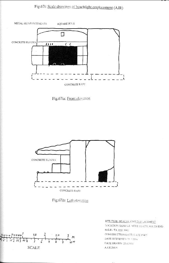
At the southern end of the beach, behind a single row of about 20 A/T blocks, is a beach light emplacement (18). This small, north facing, reinforced concrete structure, held a powerful electric light, probably protected by two large, curved sliding metal shutters. This position would illuminate the whole length of the beach if a night landing was attempted. The entrance is off-set at the rear. As with all other beach defences, sea encroachment now means that it is mostly underwater (except at low tide, when it is equally awkward to investigate, as it now sits in a large pool of quicksand – so beware).
This is a rare example and will shortly disappear forever – in summer 1995, it was at a 45 degree angle.
Behind the main double row of anti-tank blocks and sand dunes ran the most prominent feature of the site – a 300m long anti-tank ditch (16). Although this has now gone, aerial photographs show that spoil was piled either side of the ditch, with a bigger bank on the defenders side, probably to make it more difficult for any tank to climb out of the ditch once it had fallen in.
The main tactic of the defences seems to have been the use of enfilading fire, or catching the enemy in cross-fire. The location of the fire positions indicates this. On the Northern edge of the beach were a single 6 pounder (11) and 4 inch (13) artillery pieces to engage landing craft and tanks on the beach. These positions had communications / fire trenches leading to them at (10) and (12). At the southern edge of the beach was a fire trench encircled by barbed wire (22), in front of which was a weapons pit with a small adjoining slit trench (19), which could have held either an AA MG, HMG or Boys AT Rifle, again covering the A/T ditch and beach. There are no surviving remains of these positions.
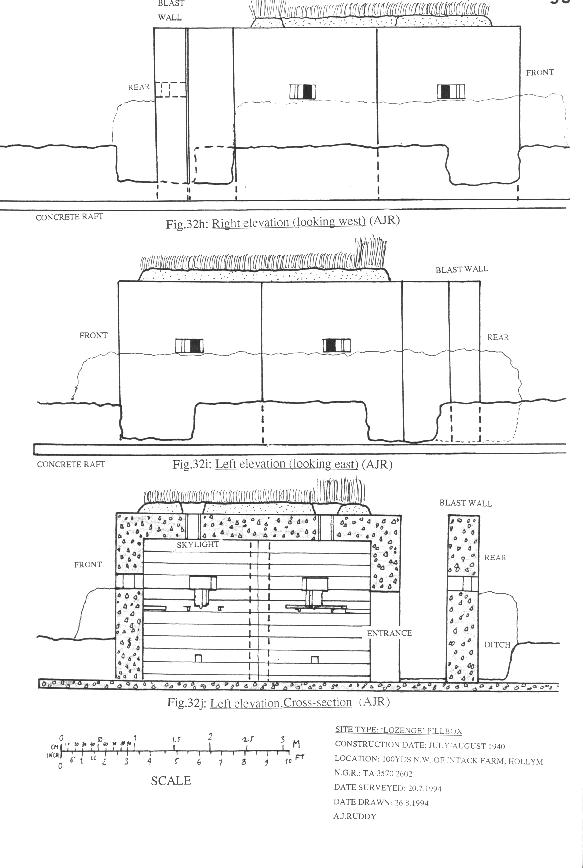
To stop any breakout from the beach, there was a back-up semi-circle of three “Lozenge” LMG/Rifle Pillboxes (See Mike Osborne’s “Pillbox Typology part 2” in Loopholes 4: p20 – the Sand-le-Mere lozenges match the ‘Easington’ type).
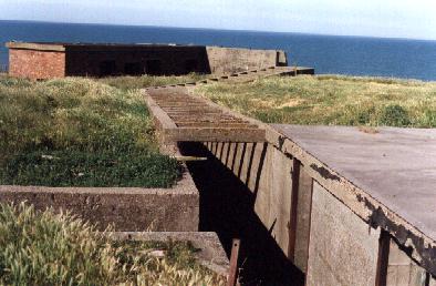
These pillboxes were on higher ground, approximately 300m inland from the A/T ditch. They are all built into hedge lines for aerial cover. These ditches at the foot of the hedges could also have been used as communications or fire trenches.
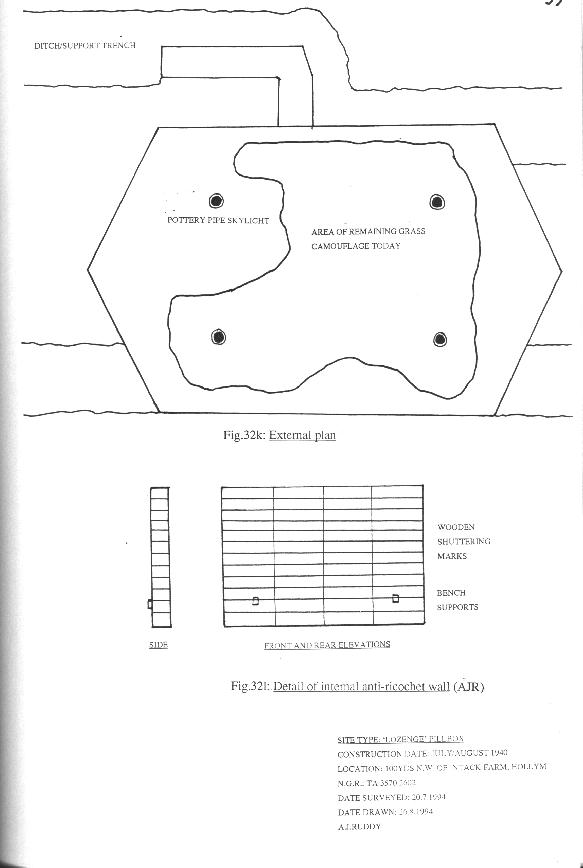
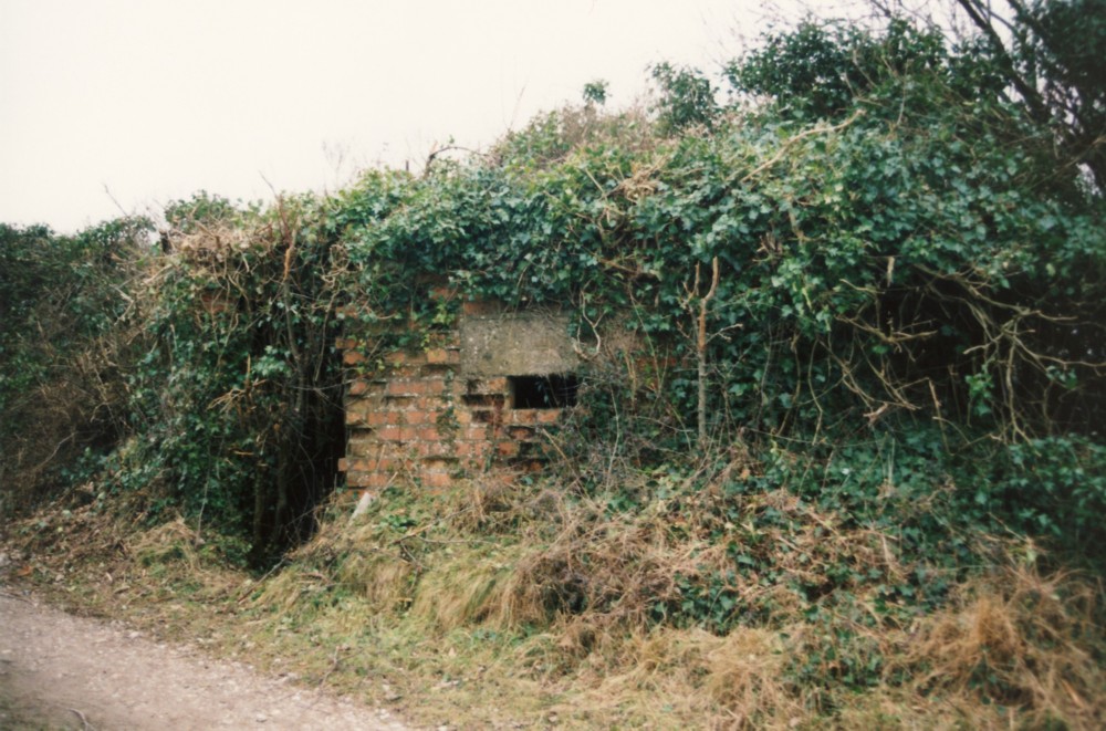
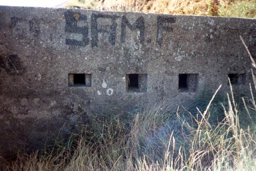
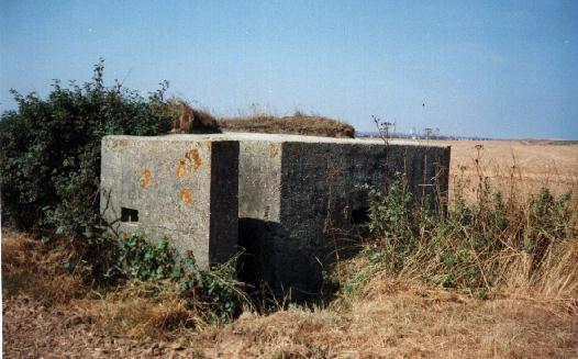
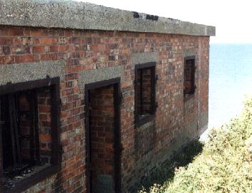
The pillboxes at (9) and (25) had a barbed wire fence around them approximately 50m away. {This unnatural circular enclosure would encourage differential growth and would be highly visible from the air, a fact which was stressed in later camouflage manuals which encouraged angular wire layouts to mimic field patterns. Editor – Loopholes}. Pillbox (26) was semi-sunken to reduce its profile and does not appear to have had a barbed wire entanglement around it. It is now bricked up. Pillbox (25) is still accessible, whilst pillbox (9) has been made into a garden tool shed, complete with door, glass blocks in the embrasures and red roses growing up the outside!
To the north of the beach were approximately 18 Nissen Huts (6). Most of them follow the hedge or ditch line and are irregularly spaced for concealment from aerial observation. This camp probably housed the garrison that manned the defences – troops of the 2nd Division [Collier, 1957: Map 17]. The camp has been completely demolished and replaced by a caravan park.
North of the beach at (2) was a substantial emplacement. It was surrounded by a large semi-circular earth bank and had four weapons pits to protect it. There was a similar but smaller emplacement 50m further north at (1). I’m not sure whether they housed artillery or anti-aircraft guns as there does not appear to be anything in them in the March 1941 photographs. They have since eroded over the cliff.
In the fields behind the coastal crust, East Riding Local Authority erected 100,000 6ft tall concrete posts as anti-glider obstructions, to stop glider borne troops outflanking the coastal defences [Wills, 1976: 41]. Some of these posts can now be seen acting as kerbs in private drives. These obstructions are not visible in the aerial photographs.
How Effective Would Sand-Le-Mare’s Defences Have Been?
As with the majority of Britain’s ‘coastal crust’ defences, it is unlikely that the defences at Sand-le-Mere would have repulsed a strong landing – as Kightly [1979:200] said, at best, they would “have done no more than delay the Germans”.
Due to the constantly shifting sands, beach minefields could not be laid. The forward facing entrances of the HMG “eared” pillbox meant that troops were not able to enter or leave them under fire, meaning they had to remain in them, and quite literally, fight to the death. It is unlikely that any major landing would have been attempted at night, except possibly a small commando type raid. The beach light emplacement (18) is strangely positioned in front of the A/T blocks, meaning that it had an unprotected rear and would have drawn much offensive fire had it used its large vulnerable searchlight.
Any landing would have been preceded by a thorough German reconnaissance and most of the defensive positions are fully visible from the air. The 4 inch and 6 pounder gun positions simply had a concrete hard standing, no bunker, meaning that they would easily fall prey to dive-bombing or naval bombardment. Once these positions had been destroyed, the experienced German Field Engineers would have either blown or ramped the A/T blocks and ditch. Alternatively, the tanks would have been able to bypass the ditch by going through the spaces at each end of the ditch (see map). If the lozenge LMG/rifle pillboxes still survived at this stage they would have had little defence against the tanks (except perhaps a Boys A/T rifle) and would themselves soon be little but rubble allowing tanks easy access to the open countryside.
The 6 inch coastal artillery up the coast at Ringborough (TA 274 373) would have been very useful in its counter bombardment/close defence role. Its range meant that it could shell craft as far away as Hornsea and Withersea. However, as Dorman [1990: 62] points out, it was not fully operational until February 1943 two and a half years after the main invasion threat. It too, would have received a thorough aerial and naval bombardment before a landing, thereby questioning whether it would have been any use anyway.
Conclusion
As proven by the Battle of Britain, it is likely that the RAF and Royal Navy would have been the only force capable of stopping an actual German invasion. Locally, as nationally, the ‘air defences’ of Holderness were the strongest and most effective part of the defensive system. On August 15th 1940, ninety nine German fighters and bombers flew towards Holderness, on their way to attack airfields inland. Radar at Flamborough Head detected them and aircraft from local bases intercepted the raiders, destroying 16 bombers and 7 fighters with the loss of one RAF fighter, causing the aerial armada to retreat back to base [Ward, 1989: 134]. Also, the Royal Navy far out numbered the German Navy.
Supposing that the RAF and the Royal Navy in the Humber had not been destroyed, then an invasion could possibly have been intercepted. However, history has taught us that the Germans would not have invaded until both these forces had been destroyed, so defence would have been left to the coastal defences – a sobering thought.
Despite severe coastal erosion, the Holderness coastline is extremely rich in twentieth century military archaeology, with various wartime coastal artillery batteries, ‘Diver’ anti-flying bomb sites, RAF/RNAS airfields, as well as post-war ROC underground monitoring posts and even a ROTOR bunker – all well worth a visit one weekend! (Sponsored by the Holderness Military Archaeology Tourist Board!!!!)
I would like to thank Roger Thomas of the RCHME for his advice and interpretation of the aerial photographs, Sam Watson for his invaluable guidance and hospitality around Withernsea, David Clarke (FSG) and John Hellis (Pillbox Study Group) for their general guidance on defence matters. Finally, I would like to thank all the un-named locals who freely offered information about the area in wartime (personal communication).
Any enquiries, suggestions or questions are welcome to:
Austin J Ruddy
This web-page is taken from a 15,000 word final year Archaeology dissertation, entitled:
“What was the British Defensive response to the threat of invasion in 1940-43: A case study of military fortifications along the Withernsea Coastline in East Yorkshire”.
Single copies of this dissertation are stored at Leicester University Library.
All field work research was carried out in July 1994 and August 1995.
Bibliography & Sources
Collier, B. 1957: The Defence of the United Kingdom, London: HMSO
Dorman, J.E. 1990: Guardians of the Humber: The Humber Defences 1856-1956. Humberside Heritage Publications NO16: Humberside Leisure Services.
Fleming, P.. 1958: Invasion 1940, London: Hamish Hamilton
Fortress Study Group Database Group, 1992: Holderness Pilot Study
Kightly, C. 1979: Strongholds of the Realm: Defences in Britain from Prehistory to the Twentieth Century, London: Thames and Hudson
Macleod, R and Kelly, D. (eds) 1974: Time Unguarded: The Ironside Diaries 1937-1940, Connecticut: Greewood Press.
Ward, A.: A Nation Alone: The Battle of Britain 1940 London: Osprey.
Wills, H. 1976: British Invasion Defences, After the Battle Magazine 14, p34-46.
Wills, H. 1985: Pillboxes: A study of UK Defences 1940 Lee Cooper/ Secker and Warburg.
Also Loopholes 4, Journal of the Pillbox Study Group – May 1993
Aerial Photographs:
28/7/1940: Sand-le-Mare: Film 613A/BRI3/1, Frame: A30, Lib. No.6742
24/3/1941: Sand-le-Mare: Film 613E/BRI74, Frame: F15, Lib. No?
From: NMR Customer Services< NMR Air Photographs, National Monuments Record Centre, Kemble Drive, Swindon, SN2 2GZ (Tel. 01793 – 414732)